Sunday, May 26, 2013

Chomped by the North Carolina Alligator

. . . HIGH WINDS, HIGH WAVES, SHALLOW DEPTHS    


From past posts, you know we believe in waiting for weather windows before traveling. Sometimes though our best plans go wrong. We left a quiet, calm Pungo River Friday morning, planning to travel 20 miles through a canal and then 20 miles up the Alligator River to the Alligator River Marina past the swing bridge. We checked the weather Web sites. All called for NW winds starting at 10-15 mph, building in the late afternoon to 20-25. Because we left early, we hoped to miss the 25-mile-an-hour winds, but had been in them often before and weren’t concerned.

The first half of the day was pleasant, light winds, mostly on our nose, keeping us from unfurling the sails. When we turned onto the Alligator River, the wind clocked around, too, staying on our nose. It was still a quiet trip with slightly higher winds and waves. Within 30 minutes, it began to build. Winds reached 20. Then they grew to 30. A front was visible from the NW that we expected to move through and then the wind to subside.

We didn't risk our cameras in Friday's high wind and
waves. These one to two-foot waves and troughs are
from an 11 mph wind on Sunday. Imagine what they were
 like with wind four times higher.
The Alligator River is shallow, some nine feet deep. When the wind builds even a little, waves there become steep and close together. In a larger blow, they are impressive in size and constant. Within 90 minutes from the time we turned onto the river, the winds were howling at a steady 40 mph (35 knots) and with waves of around five feet crashing on our bow and dodger. Our concern became the wave troughs that were about five feet deep -- too close to our four-and-a-half foot keel. 

The single front seemed to have spread all around us, without bringing rain, just more wind.

As we traveled on up the river, the winds hit 49 mph (43 knots) and the waves grew higher. We found we were only making two mph headway, which would put us in the marina late at night after it had closed.  At that point, we decided to turn Carina around to join a couple anchored where the river and canal met, 10 miles back. 

Were we scared? Greatly concerned. We wore our life jackets for the first time on the trip.

We Were Pooped

Retracing our path was almost as exciting as the trip out. Just as the wind and waves had been on our nose before, they were dead on our stern going back. And with the grayness all around us, it became harder to see the crab pot floats. We barely missed a couple of them. If we’d run over one, its line could have wrapped around our prop and stopped the engine. After the near misses, we kept a better lookout.

The waves would roll up against the back of the boat, floating the dinghy hanging from the lifts. At one point, we both looked at our feet and realized we were standing in three inches of water. We weren’t sinking. The water drained away. We weren’t in danger, but were “pooped.” That’s a sailing term for getting waves from the stern into the cockpit. Carina has a sugar scoop stern, very open and great for getting on and off. She was built as a comfortable coastal cruiser, rather than an ocean-going boat. From another Catalina owner, we knew that her sugar scoop can make her a wet boat in large following seas and quickly put the hatch boards in to keep the cabin dry. We were pooped several times on the return trip when waves swept into the cockpit.

Song of Pogo was also anchored with us Friday and
Saturday under a full moon.
The anchorage was slightly protected although the wind was still howling and the waves still choppy. We dropped the hook and were thankful for being secure for the night. For the rest of the evening, we listened to the Coast Guard handling VHF distress calls from boaters less fortunate than we were.


Over the next day at anchor, it occurred to us that even if we'd made it through the Alligator River on that first attempt, we couldn't have gotten to the marina. The bridge before the marina wouldn't have opened for us, and there was no secure anchorage nearby. NC bridges don't open in winds of 35 mph or more. 


Friday's "red skies at night" forecast
 better weather.
What would we have done differently? It would have helped to check the weather for updates around noon. But we had no cell bars for our smart phones or laptop to work. We did what sailors without electronics have done for years -- use judgment and experience to make a decision. In this case, we think it was the right one.


Friday, May 24, 2013

Nothin' Could Be Finer Than To Be In North Carolina

. . . FROM THE GRAND STRAND THROUGH THE PAMLICO SOUND


One of the best things about traveling the Great Loop is seeing the countryside. So far, every part of the Atlantic Intercoastal Waterway (AICW) has been beautiful although we have favorites. We really loved Florida’s white sands and blue water. Georgia’s and most of South Carolina’s stretches of the ICW were unique with vast marshlands, nine-foot tides, and dense mud banks.

The closer we got to the northern end of S.C., the more sand we saw, the lower the tides (down to four feet), and the taller the trees along the water. As we started to get used to that terrain, suddenly the ICW narrowed near Myrtle Beach and became a cypress water trail that we took to Osprey Marina.


Spanish moss, the last we saw, hung from cypress trees in a winding water trail, part of the AICW. Although blue in the photo, the water was actually brown with tannin from the trees. We'd also traveled in tannin waters in Georgia and S.C.


Boats in this part of the country develop a mustache from the tannin in the water. This boat has a particularly good one. At the Chesapeake Bay, we'll be out of the brown waters and will try to remove Carina’s mustache with acid -- orange juice. Some over-the-counter formulas take off the bottom paint, too. 


Osprey Marina


For months, we’d heard from our cruising friends, including Yasmine and Roy who were meeting us there, just how wonderful the Osprey Marina was. We finally got to see it with our own eyes. What surprised us when we reached it was how small, homelike and safe it was. By safe, we mean it’s considered a hurricane hole. (A hurricane hole is a bay, harbor or marina where your boat can be fairly protected if a storm approaches.)


Yasmine and Roy (with Kent, left above) have a beachfront condo on nearby Myrtle Beach, a 20-minute drive away. If all goes well, sometime in late summer they will be living and working full time on their Lagoon 41 catamaran, Yasmine Anne, going wherever the wind blows and the Internet signal is strong. They’ve been busy renovating their condo to rent and their boat to live on – all while handling a full-time job.

They were amazing hosts through our stay and took us for an amazing meal that last night. Charlestonians claim the best Shrimp and Grits. Yasmine and Roy showed us that the best is in Myrtle Beach. Truffle oil makes the difference.

We're hoping to see them again in New York State, if everyone's timing works out.

The State of Surprises

North from Myrtle Beach is the North Carolina state line where the AICW moved back closer to the Atlantic. The coastal towns are very beach-like and appealing.

Also appealing is the honeysuckle. For the past week, when the ICW narrowed, the smell of honeysuckle on the banks would drift over to Carina in waves. It was wonderful.


Cruising in North Carolina has more variety than the two states before it. The current changed mile by mile, sometimes with us, sometimes against us, depending on the state of the tide, inlets open to the ocean and rivers feeding the ICW route. Crossing the large, sometimes lumpy Pamlico Sound is under our belt, with the Albermarle Sound to go this weekend. North Carolina has two of the six largest bodies of water to cross on the entire Loop.


At Mile Hammock anchorage – you could call it the Camp LeJeune stop, a V-22 Osprey practiced and practiced and practiced. Often the ICW is closed when the Marines fire or conduct maneuvers across the river. We were lucky and were able to travel through the next morning.

Because of the tilt-rotors, the Bell-Boeing Osprey can be used as a helicopter 
or airplane in rescue and combat missions.


Maybe they should add another sign: If you're close enough to read this sign, you're too close to the firing range.


The North Carolina leg of our journey will end after we go through the Dismal Swamp early next week. Marines. Swamps. Eagles. Large shallow sounds to cross. Beaches. Cypress water trails. And lots and lots of history. North Carolina has surprised us. It's been interesting from the start and, we expect, to the finish.


Monday, May 20, 2013

A May Bouquet of Flowers and Birds

. . . SPRING ALONG THE GREAT LOOP


Here's our gift to you -- photos of the flowers in bloom and birds migrating or nesting that we've seen this May. We hope you enjoy them as much as we did.


Honeysuckle, Osprey Marina, Myrtle Beach, South Carolina


Shasta daisies, Deep Point Marina, Southport, North Carolina.

Gaillardia, Deep Point Marina.


Coreopsis, Deep Point Marina.

Oooh-la-la! It's springtime! Laughing gull pair 
shares a post, Deep Point Marina.

A solitary laughing gull, laughing, Deep Point Marina.

A pelican gets its fish, Charleston Harbor, South Carolina.


God must love cormorants because he made so many. A cormorant dries its wings, Wrightsville Beach, North Carolina.


Osprey building a nest, near Osprey Marina, Myrtle Beach, South Carolina.


Osprey in its nest, near Osprey Marina.


A migrating ibis, Deep Point Marina. Its bill and legs become red in mating season.


A swallow uses the pool as its own fresh water pond, Deep Point Marina.


Bald eagle, on ocean inlet marker near Bald Head 
Island (no joke), North Carolina.

The eagle from the side. We see them so rarely that
it's a thrill when we do.


Thursday, May 16, 2013

Doing the Charleston!

. . . EXPLORING THE LOW COUNTRY WITH FRIENDS


Kent raises the anchor on Tom Point
Creek at high tide.
After leaving our friends, Hamp and Denise, in Savannah, we traveled a couple of days by ourselves through the Lowcountry. That's what the tidal marsh area on the coasts of Georgia and South Carolina is aptly called. Tides continued to be eight feet (compared to one or two feet on the Gulf Coast), causing strong currents as the huge volume of water ebbs and flows. Low tide revealed deep, long, "gumbo" mud banks -- and shoals that weren't visible in high tide.

Friends Chuck and his wife, Janie, met us 
Friday at St. John's Yacht Harbor, near Charleston. We really like meeting new people along the way, but seeing friends we've known for awhile means so much. Chuck and Janie drove over from Georgia and were our tour guides for the visit.


             Chuck, Janie and Kent enjoy docktails on Carina near Charleston.

Reasons to Go Back

When visiting the Keys, we would say that if we saw everything, we wouldn't have a reason to come back. We definitely have reasons to go back to Charleston. We saw a lot, but there's so much more history to see.


Old town Charleston as seen from Charleston Harbor. Charleston's business district is as modern as any other city's. City planners and residents have kept the historic flavor of buildings in the older parts of town, even when they are newly built.


This beautiful older home -- or is it just older looking? -- is one of many that line certain sections of the harbor.


At first, we thought this was Fort Sumter, but learned it was Pinckney Castle. The castle was built as a fort in the early 1800s, although it never saw a shot fired in anger. When the Confederate forces took over Ft. Sumter, Pinckney Castle was used to house Union captives. We've read that at high tide, the jailed soldiers stood in waist-high water 
inside their cells. 


The ferry to Fort Sumter approaches the island. Private boats aren't allowed to dock there. The fall of the fort was the start of the American Civil War. The U.S. flag flies above the
 many versions of the Confederate flag.


The Confederate H. L. Hunley was the first submarine ever to fire and sink an enemy ship, the U.S.S. Housatonic, in 1864. The sub disappeared shortly after it fired on the ship, never to appear again until it was found in Charleston Harbor in 1995. While on display, it is still undergoing extensive conservation. The sub sits in fresh water charged with electrical
 current to clean a century-worth of barnacles and sediment.


This model of the Hunley sub shows the cramped quarters of the captain and crew. The Hunley had three separate crews from the time it was first built. The sub sank twice while being tested, was raised twice and put back into service each time with volunteers. From her start until 1864, 21 crew members died. What courage it must have taken for that last group of volunteers to climb into the sub, knowing its history.


By contrast, the U.S.S. Clamagore is a World War II-era submarine on display at Patriot's Point in Charleston Harbor. It has an almost 2,000-ton displacement, compared 
to 7.5 tons for the Hunley. 


As monstrously big as the U.S.S. Yorktown is, it's small by comparison to today's aircraft carriers. The Yorktown was built in just 16 months at the height of World War II, earning a total of 16 battle stars for its service there and in Vietnam. The carrier was also used in recovery of the Apollo 8 space capsule.


Chuck and Kent walk the Yorktown flight deck where thousands of planes went to war
 to protect our nation.


After leaving the wonderful St. John's Yacht Harbor where Carina was docked a couple of days, we entered Elliott Cut, a half-mile canal that leads to Charleston Harbor. It's been described as one of two of the most dangerous cuts on the Intercoastal Waterway. Because we left on a rising tide, we had no problems there or when entering the harbor.


The hurricane regulations sign made us laugh. The sign has seen one 
too many hurricanes.


Our next stop (after a few anchorages) is Osprey Marina. We're meeting Roy (aka Turtle Boy) and Yasmine, two good friends from Marathon, at Myrtle Beach where they have their land home, a condo near the beach. It will be good to see them again. They have gotten the "Keys disease," too -- a love of the laid-back life in a warm climate.


Tuesday, May 14, 2013

What Has and Has Not Worked For Us So Far

. . . 5 GOOD AND 3 NOT-SO-GOOD ADDITIONS


Our cruising friends may be more interested in this list than our land friends. Stan and Annie, who have done the Loop twice, asked us: what has worked and what hasn't on Carina? We're slow to answer, but here goes:


What Has Worked 

Carina with most of the things that have worked -- the
stainless steel lifting davits holding the dinghy up, the
bimini and back curtains, and the (hard to see)
solar panels.
Bimini, wind/sun/rain panels, dodger -- Every day we are grateful for the bimini over the entire top of the cockpit, the panels that attach to the side and back to block much wind, sun and rain, and our dodger that stretches across the front of the cockpit. That's no joke, every day. At some time, we'd like a total clear enclosure like many cruisers, but are very happy with what we have. 


Solar panels -- When we were on the mooring ball at Marathon, the solar panels provided the power we needed. Now that we're underway, our energy cup runneth over. 

Lifting davits for the dinghy -- From the time we installed them, they have worked great to lift the dinghy out of the water, keeping the bottom clean of barnacles and reducing the drag on Carina as we're underway. Enough said. 


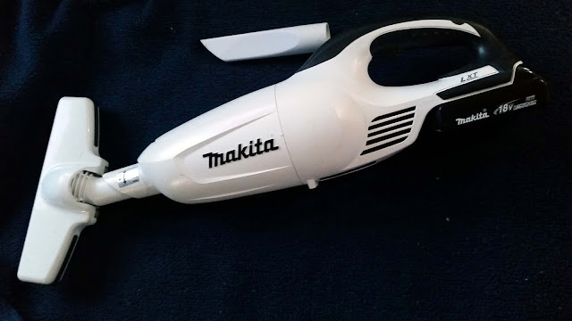
The Makita vac is easy to store. The attachments separate from the body, and everything can be stored in a small bag.

Makita cordless vacuum -- Practical Sailor recommended the Makita BCL 180W 18-volt Lithium-Ion cordless vacuum, and we do, too. It's battery operated, rechargeable, small, dependable and has all the power needed to keep our sailboat clean. The few power tools on board are Makita, too, so we can use one charger. 


Microfiber fabrics -- Longtime cruising friends Phillip and Sharon told us they do not carry cotton on their sailboat. After experimenting on "shake-down" cruises, we saw the value of their ways. Our microfiber towels and settee cushion covers are easy to wash and quick to dry, something that can't be said for cotton. Before our trip started, we slowly replaced cotton shorts and T-shirts with performance fabrics. They are made of man-made synthetics that pack smaller than natural fabrics. Walmart, Target and TJMaxx carry them, so they don't have to cost a fortune. 


Our microfiber boat towels are from Target (the automotive and sporting goods areas) and the wash cloths from Dollar Tree. You don't have to spend a lot of money.


What Hasn't Worked

Thanks to several shake-down trips, we haven't had many flaming failures on this one. The disappointments we had are:

 GREAT CART! Get this if you have  
space. It holds items without 
having to strap them on.
Movies on an External Hard Drive -- To save space, our DVDs were copied onto an external hard drive to carry with us. The external hard drive seemed like a great solution because it's more compact than 100+ DVDs. It played the downloads well at home. Once on the boat, it didn't work. This one can probably be chalked up to user error and may work well for others. On the flip side, the external hard drive stores all of our photos with ease.


Carina's microwave oven -- Carina came to us with a tiny 10-year-old microwave that fit perfectly in a slot above the stove. It could only be used when we were hooked up to shore power at a dock, limiting how often we were able to cook with it. Within two months after the trip started, it stopped working. And that size microwave oven is no longer manufactured. It's now a peanut butter and jelly storage unit. 

Folding hand dolly -- It's a heavy-duty plastic dolly that many marine stores sell. However, groceries or laundry are hard to strap on it. They fall off. A personal rolling grocery cart like ours from Kmart makes it easy to carry clothes, groceries, gas canisters or other things to and from the boat. It also can be tied with bungies onto the back of our folding bikes and acts as a bike trailer. The cart folds, generally fitting the same space as the hand dolly.  


We hope this list helps somebody else planning a long cruise. At the least, we hope it answers Stan and Annie's question.


Wednesday, May 8, 2013

Of Friends, Feral Hogs, Storm Fronts and Haint Paint

. . . TRAVELING THE COAST OF THE PEACH STATE


Looper friends, Hamp and Denise on Gracie, introduced us to the beautiful Georgia town of Darien. We left the Intercoastal Waterway, motoring seven miles up the Darien River to tie up to the city’s free dock (free power and water, too!). 

Hamp and Denise met us on the dock, later taking us on a tour of the town. They grilled Cornish game hens and treated us to a great evening. It seems we weren't the first to discover how gorgeous Darien is; when we sent our boat locator notice that evening, several friends told us how much they liked their trips there.  


We met Denise and Hamp at a Marathon get together for boaters doing the Loop. It was well publicized with 125 people showing up. It turns out we're the only two boats among all those people who are actually doing the Loop. The rest were there for the party!


Darien is very accommodating to boaters, offering three days of free docking. The trimaran at the end of the dock is Ra, a completely solar-powered boat doing the Loop (solarboatchronicles.com).


The town has a town circle with angel fountain, town square and small shops. 
Live oaks and Spanish moss make it feel like a well-kept park.

Man plans. God laughs.

Our plans were to leave early the next day, cross several sounds (or bays) and reach Savannah in two days. Because a front was moving through, we kept a close eye on weather, wind and tide forecasts. The winds increased steadily all morning the day we left Darien until they reached 25 with gusts of 35 mph. We decided to tuck into an anchorage that Denise found on her iPad charts – Crescent River, instead of risking the open-to-the-Atlantic Sapelo Sound crossing that day. It was a good decision.

The big front that went through brought high winds and waves lapping at the hulls of the boats non-stop for two days. Most boaters were holed up like we were, except for a few crazy souls. One trawler radioed another that he was seeing gusts of 50 mph on his anemometer that reads wind speed. A line of trees helped break the force of the winds in our anchorage, but they were still mighty strong.

Two days of strong winds were followed by two days of rain and lighter winds. We know that the rest of the eastern U.S. was having bad weather, too. It’s a little harder though when you are confined to a cabin. We figured that cabin fever originated from staying winters in log cabins. Maybe it really means the cabin of a boat.


How did we entertain ourselves? By watching feral hogs feed at low tide. At high tide, the land was under water.


A nearby dock in the Crescent River was almost under water during the height of the storm and height of the tide.


Escape from Crescent River

Our clothes were dirty, groceries and water low. After a full four days, the forecasts were good for a crossing of the sound. We gladly pulled anchor and left the Crescent River. Traveling across the Sapelo Sound was uneventful because we worked with Mother Nature instead of against her. After one more evening at anchor, this time in Cane Patch Creek, we reached Thunderbolt Marina slightly south of Savannah. Washing machines! Grocery stores! Water!


Morning at Thunderbolt Marina means finding a half dozen Krispy Kreme doughnuts on your boat. It's not a really healthy breakfast, but it's okay to treat yourself now and then. Another marina provided us with a local paper and two blueberry or apple muffins. Those marinas are the exception rather than the rule. 


Hello/Goodbye -- Savannah in a Day

Once again we only had just a few hours to see an entire city. We didn't do justice to the beauty and history of Savannah, but at least we got an overview. It's worth spending much more time in than we were able to -- this trip. 

The one fact to know about Savannah after reading this post is that the Savannah College of Art and Design is a monstrously big school that is having a huge influence on the culture of the city, the stores that locate in Savannah, and naturally on the students that attend.


A Georgia peach of a tour guide -- Karen -- and our friend Denise stopped in front of the trolley that took us around Savannah.  


The home of antique dealer Jim Williams, who figured prominently in the Savannah-centered, non-fiction book, Midnight in the Garden of Good and Evil.


The oldest house in Savannah is the Pirate House, circa 1734. The shutters and door are done in "haint paint," as were many ceilings. The Gullahs of the Low Country believed that spirits can't cross water and used blue paint as a symbol. Back then, the paint contained lime that we were told repels mosquitoes, a carrier of diseases. So in many ways, the haint paint did protect the Gullahs  from evil haints that could give them malaria and yellow fever.


The architecture in Savannah is incredible! For example, the Telfair Academy was a private home built by British architect William Jay. It was left to the city and was converted to an art museum. The statues are of Phidias, Raphael, Rubens, Michelangelo and Rembrandt.


At Thunderbolt Marina, we said we'd see each other soon. Hamp and Denise are staying another week, while we sailed out today to meet friends and former co-workers in Charleston. We hope our paths cross sooner rather than later, but we're certain that they will cross again.