Sunday, June 23, 2013

New York, New York is a Helluva Town

. . . THE BRONX IS UP AND THE BATTERY'S DOWN


We'll vouch for it being a helluva town. After almost 4,000 miles and nine months to get here, including a three-month stall out in the Keys, we finally made it to New York City.


The view of Manhattan at the southern tip or the Battery. We'd always heard that Manhattan was an island between the Hudson River and the East River, but didn't know that the East River was partially man-made.


John, Great Kills Yacht Club harbor host, loaned us his MTA card to use on public transportation to reach the city. What made the biggest impression on Kent were the huge masses of people and how efficiently public transportation moved them wherever they needed to go. 


For three days, we took taxis, the Staten Island railroad, the free Staten Island ferry, and then subways all over town.


A main transportation hub of Manhattan is Grand Central Station with subways and trains running constantly. Kent was amazed that the subway system was as much as three levels below the street, such as at Grand Central.


On second thought, public transportation made the second biggest impression. The biggest impression was made by our Grayline Tours bus driver who managed to navigate bumper-to-bumper New York traffic, moving around trucks and other buses with just a hair's distance between them, and stay on schedule. Kent told him it was worth the price of the ticket just to see him drive through Manhattan.

A few of the many places we visited were:


World Trade Center, 9/11 Site


The new World Trade Center is nearing completion.  The 9/11 Memorial, at its foot, draws somber, thoughtful crowds, as will the 9/11 Museum when construction is done.


On the outside wall of Fire Station No. 10, the first responders to 9/11, is this large plaque “dedicated to those who fell and to those who carry on.”


South Street Seaport


The South Street Seaport in lower Manhattan was hard hit by Hurricane Sandy with the Seaport Museum and many businesses still being repaired.  The storm didn’t appear to damage the Seaport’s ships, like the Peking, a huge commercial sailing ship built in 1911.


Central Park

Kent was impressed by how Central Park seemed well planned, very well designed , yet appeared as if nature made it that way. It was designed over 150 years ago by Frederick Olmsted who later laid out the Biltmore Estate grounds near Asheville.


Empire State Building

The Empire State Building was completed at the start of the Depression. The view from the 86th floor showed us the Hudson River where we’d travel the next day. 


Carnegie Deli

Our final meal in Manhattan was at the Carnegie Deli, home of big New York food. We had a Bacon Whoopee sandwich (Jane lived to tell about it) and their Famous Rueben sandwich (Kent). Each sandwich fed us for three meals. The photo doesn’t do justice to their hugeness. Our entire table laughed when they were brought out. Of course, they ordered food just as large.


Saturday, June 22, 2013

Along the Jersey Shore to New York City

. . . SAILING IN THE ATLANTIC OCEAN


Our Atlantic crossing took us by the Jersey shore for two days. It surprised us that Jersey was non-stop beach from the bottom of the state to the top, with a few gambling casinos in between. We’d expected a few beaches here and there, not the Florida-like shoreline we saw.


Down Time gets fueled up before leaving Cape May. Carl and Dottie had been on the Loop just a couple of months when we met them. 


Three boats left Utsch’s Marina in Cape May early Saturday -- the trawler, Down Time; 30-foot sailboat, R&R; and Carina. Winds blew from the west, with gentle three-foot swells. Although those wind and wave conditions varied in our two days on the Atlantic, they were never a cause for alarm. Thank you to everyone who crossed their fingers for us.


Peter and Cynthia on R&R, a 30-foot Irwin, had spent the winter in the Bahamas and were returning to New York State.


Down Time stopped early that first day at Atlantic City, while R&R and Carina sailed on another 30 miles or so to Barnegat Inlet farther north, a 12-hour day. Blame the long day for our adventures in anchoring. Lesson learned: we will be more careful NOT to drop anchor at the edge of the anchorage and then let out enough rode (the line that connects the anchor to the boat) so that the boat stops in the channel -- especially when a towboat is pushing a barge through that said channel.


Strong currents and shallow water in Barnegat Inlet created standing waves at the foot of the lighthouse.


The best thing about the day was the unexpected sunset concert by a bagpipe player.


More of the Same

The next day, our friends on Down Time speeded up to catch up and pass us. Trawlers can do that, even though they pay the price at the fuel dock. Both sailboats slowly motored the entire way in light to no winds to Great Kills Yacht Club on Staten Island.


R&R heeled over from the tide rushing out the inlet the next morning, not the wind.

Great Kills = Great Hosts, Great Place

Carina was able to dock at the yacht club because it made limited space available to Loopers, and they luckily had room for us.  After looking at marinas or mooring areas close to Manhattan, we decided the cost was too much ($4-plus per foot of boat per night is average) and they were too uncomfortable --rocky rolly from currents and hundreds of ferryboats.  Staten Island where the yacht club is located is fairly close to Manhattan – close enough it seemed to us.


Over 100 years old, the club was described as a working club, just like Privateer. Klaus, a 35-year member, told of some of its colorful history that at one time in the '30s included the Mafia. Only in New York! (And probably Chicago, LA, . . .)


The decision to stay at Great Kills Yacht Club was a good one. We met friendly people and found a club similar in many ways to ours in Chattanooga. The boat and Squirt were safe when we were gone. The area is beautiful with a strong sense of community. And it was just a train and ferry ride away from Manhattan.


John is the official Looper organization harbor host for Great Kills. He was quick to offer information, rides for fuel and to the train, and other help.


Recovering from Hurricane Sandy

Signs of hurricane damage are still around. Along New Jersey’s shore, hotels and restaurants were mostly repaired, although many backhoes and much scaffolding was in sight. The famous Atlantic City Boardwalk that was destroyed has been rebuilt and is welcoming visitors again. TV ads run frequently to let people know that New Jersey is open for business.

It’s not just New Jersey. Surrounded by land on almost all sides, New York's Great Kills Harbor couldn’t withstand hurricane force winds. Boats were mangled. Docks were torn apart. But the people there and elsewhere in the area are resilient. Yacht club members have put their docks back together better than ever. When a repaired boat is put back in the water, it's a time for celebration at the yacht club. They still have quite a few celebrations to look forward to.

Sunday, June 16, 2013

Up the Chesapeake, Down the Delaware

. . . ONE'S A BOATER'S PARADISE. THE OTHER IS. . . NOT


Most people have heard that the Chesapeake Bay is a sailor's paradise. After getting past the big waves and winds at its broadest, southern-most point, we agree. It's a place we'll return to, maybe even bringing a smaller boat here to do more sailing and gunk-holing (shallow-water exploring).

Hardly anyone has heard about Delaware Bay. It's sort of the Rorshach test view of the Chesapeake, and it's not boater friendly. But Loopers have to travel up the length of the Chesapeake and then down the length of the Delaware on our journey.


Sunset on our first day on the Chesapeake, a 50-mile travel day. The landscape began to look more like Tennessee. Winds were 25 mph and gusting, and we had uncomfortable following seas (seas that hit us from behind the boat and at an angle). We used to like following seas until we had heavier versions on the turnaround trip on North Carolina's Alligator River and on the first part of the Chesapeake.


When the weather is good, we anchor out. When not, we find a marina or really protected anchorage. The weather hasn't been very good lately. After anchoring out the first night, we learned of a front with high winds and rain heading our way and that led us to discover Ingram Bay Marina, a small, relaxed marina just south of the Potomac River. Think campground and not stuffy resort marina. Their loaner car is a red pickup truck. We were soooo happy to have a loaner car, errrrh. . . truck to get provisions.


Captain Billy (left) and Jane share something in common -- both graduated from the University of Alabama and are still huge football fans. Captain Billy and his wife, Mary, own and manage the marina and some 17 acres of farm and field around it. He has a busy fishing charter business, too. He is one of the most helpful, sincere, positive people we've met on our trip. We felt at home at Ingram Bay Marina and will be back. 


A swallow claimed the boat line to the dock next to Carina. He/she was there night and day when not out hunting bugs.


After leaving Ingram Bay, we came across several wonders along the Chesapeake, such as this gigantic channel mark for ocean-going vessels. That was its original purpose. It's used most often as a cormorant wing-drying station with an osprey family in the penthouse apartment.


We thought these poles were a derelict dock, but Captain Billy told us they are a pound net to catch fish. Look closely to see the nets strung among the poles. A fish swims into the outside net and is funneled by a series of nets into the center. One of the oldest ways of catching fish, pound nets were used by Native Americans for centuries. Pound nets are common in the area around the Potomac River.


The number and variety of lighthouses were a surprise. This lighthouse was on the way to the Solomons after leaving Ingram Bay. These lighthouses were staffed years ago. We think we know what the little house was used for that's perched half off the platform. What do you think?


Friends of ours described the Chesapeake as being "like a mirror" when they crossed it. We didn't understand at first. It was pretty rough to us at the start. Then, the Chesapeake showed us it could be calm. A third of the way down in this picture is a horizon. The water is so calm and perfectly reflecting the sky that the two blend into one.


U.S. Naval Academy midshipmen stow the jib after a sail on Chesapeake Bay. Annapolis, where the academy is located, is about midway up the bay. The cargo ship behind them is anchored and is no danger.


After Tropical Storm Andrea moved through the Annapolis area, we met up with Joey and Jim (who are sandwiching Kent), friends we met in Marathon. They left the Keys to sail to the Bahamas for about five weeks. When we passed through, they kindly showed us Annapolis, Md., part of their favorite sailing area. Days later they took us on a tour of Cape May, N.J., near their home.  We met at the tiki hut at Boot Key Harbor and were in many conga lines together there. They clean up so well!


Annapolis is all about the harbor and being on the water. It's about state politics because it's the state capitol. And it's about the U.S. Naval Academy.


The Chesapeake is the place to go to see all sorts of sailboats, large or small, wooden or fiberglass, ketch or sloop or cutter.


After leaving the Annapolis area, we sailed a little farther up the Chesapeake and turned right (East) onto the C&D Canal. The first stop was Chesapeake City, a very pretty anchorage and town on the man-made ditch between Chesapeake Bay and Delaware Bay. Another rain front was predicted to pass through.


Kent had a line out for crab during the rains at Chesapeake City when he caught this catfish. As happy as he looks, he released the little fellow a minute later. 


Most marinas are nice Motel 6s, some a nice Marriott. They are just a place to stop on the way. The marinas that help us in our travels like Ingram Bay Marina on the Chesapeake and Delaware City Marina are those we value. Corey and Delaware City Dockmaster Tim turned Carina on the dock to help us leave easily the next morning. Tim also holds an evening get-together about how easy -- or hard -- it will be to travel on Delaware Bay the next day. Most
marinas don't provide advice like that.


After months of Loop travel alone (after Hamp and Denise stayed at Thunderbolt Marina), we finally met a couple of other Loopers -- TerrMar IV and Down Time at the Delaware City Marina. Carina is the peanut in back. Dockmaster Tim also helped us get rid of Carina's ICW mustache from Georgia, South Carolina and North Carolina water.


Delaware Bay has the reputation of being a nasty piece of water to cross. Tim said that no one would have white knuckles if they sailed/motored down the Delaware the next day after we arrived. He was right. Not only did we have a tidal assist in speed, but the wind and waves helped, too. At one brief point in the 50+ mile day we reached 12 miles an hour (the number in the upper left corner). Typical traveling speed is 6.5 or so. 


Another striking lighthouse, this one on the Delaware Bay.


In one 50-mile day, we traveled the entire length of the Delaware Bay, arriving at Utsch's Marina (pronounced Uh-chiz) in Cape May, New Jersey, near our friends Jim and Joey. Live eels, anyone?! Cape May is a huge fishing area, and eels are great bait, so they say.


Some things we learned about Cape May are: The Abbey is one of hundreds of beautiful Victorian buildings and homes in Cape May. The community covenants make sure new buildings conform to the look and feel of the Victorian era.


Victorian-looking homes along the harbor fit in with the older homes in downtown Cape May. 


Cape May is the oldest seashore community in the U.S. with beautiful golden sand, blue water and warm sun . . . after May, of course.


The Cape May Lighthouse became operational in 1859 and is still active to alert mariners today. It's a more traditional lighthouse than the others in the Chesapeake and Delaware Bays.


By the time you read this, we will have left Cape May and entered the Atlantic Ocean, our first outside crossing. After a stop or two, our ultimate destination is New Yawk City -- as the salsa commercial says. 

We've crossed the shallow Gulf. This will be our first step into the deep, unpredictable Atlantic. Please wish us luck. Whether we need it or not, we truly thank you for it.

.


Saturday, June 15, 2013

How Safe is Cruising in the U.S.?

. . . THE PRECAUTIONS WE TAKE


Our land friends let us know they are concerned about our safety. Some mention pirates, with a laugh. Luckily, there have been no recorded pirate attacks for more than a century in U.S. waters. 

Joking aside, we really don't have an answer to the question about safe cruising. We've had a good experience, no worries, no problems, in the half of the Great Loop we've done so far. All we've read and heard about our route is that there's no need for protection from anything but the weather. 

However, in a place as small and safe as Marathon where we moored three months, a robber came on board several boats at night -- usually with the owners asleep just a few feet away -- stealing generators, dinghies, fishing rods and other items that weren't secured. The local police caught the thief ("he weren't from around these parts") and returned the stolen items. When the robberies began, the rest of us began to lock items as a precaution. 


Taking Precautions

What we learned from Marathon is to clear the cockpit or lock away easily stolen items before leaving the boat or going to sleep. Put the hatch boards in the companionway (main doorway) and lock the boat before leaving it. 

Stan and Annie, our most-experienced Looper friends, suggested clearing everything out of the dinghy before taking it ashore in larger cities. That means that the pfds we wear in the dinghy to make us Coast Guard-legit for navigation must be worn or carried on shore. Naturally, lock the dinghy to the cleat when ashore.

Protecting Ourselves on the Boat

Don't mess with me!  Grrrrrr.
Go ahead and laugh, but Squirt's 100-pound bark in a 10-pound body is one of our best lines of defense. His bark attracts attention and startles "evildoers." People are less likely to rob a home, apartment or boat with a dog there. That's why he's Chief Security Officer.

Other ways of protecting ourselves are cans of wasp spray and bear spray that we can grab at the entrance to the cabin. In the V-berth, we keep a couple of air horns, another bear spray and a flare gun and flares as attention getters for other boats, thief distractors, and protection.


To make noise and incapacitate a thief, we have wasp and hornet spray, flare gun and flares, air horn, and bear spray on the boat. We could also grab a fire extinguisher to temporarily blind someone, if need be.


Why No Guns?


Carrying guns is an emotional topic to boaters, just as it is to people ashore. We chose to have defenses that are legal everywhere that we plan to visit, including New York City and Canada that ban guns. (Yes, Canada has bears, so they allow bear spray.)

Our combined defenses provide peace of mind to us and we hope to our family and friends. For sure, you can take comfort knowing we'll be bug and bear free while we're traveling.

Wednesday, June 5, 2013

Fascinating Norfolk*

. . . THE CITY OF WARRIORS AND MERMAIDS


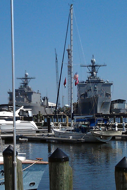
Put it down to old-fashioned flag-waving, but seeing our country's military might is awe-inspiring to us. Few places have caused us to be in as much awe as Norfolk, Virginia, home of a huge U.S. Navy base. Entering the Elizabeth River to downtown Norfolk is jaw dropping because of all the destroyers and supply ships looming over us on dry dock. We learned that those ships are nothing compared to the number of active ships docked at the naval shipyard. 

Carina was safe at Waterside Marina in the shadow of U.S.
Navy warships at dry dock.


After tying up at a downtown marina, we got fuel, a pump out, and did laundry. Joe, son of good friends Bob and Trish, was kind enough to help us make a rum run. We've heard about Joe and his family -- who live in Norfolk, by the way -- for years from his folks, and it was wonderful to finally meet him in person.

After boat chores, we had fun touring the Hampton Roads Naval Museum, a free museum on the history of the Navy in the Norfolk area. The Civil War battle of the two ironclads -- the Monitor and the Merrimack -- took place just outside of the city.


The U.S.S. Cole was repaired after the bombing that
opened a hole in its side and killed 17 people. 


Later that day we took the naval base cruise that took us by several miles of ships. The most famous were the U.S.S. Cole, the destroyer damaged by bombers in Yemen in 2000, totally repaired and back in business, and the U.S.S. Enterprise aircraft carrier. 


We remember the Enterprise from the times it recovered capsules as part of our space program. The carrier was involved in the Cuban Missle Crisis, Vietnam War, and Operation Iraqi Freedom. This year, it was decommissioned and is being disassembled. Soon it will be sold for scrap metal. 


The Big E is the longest naval vessel in the world and was the first nuclear-powered aircraft carrier. It had a crew of 4,600 sailors. Probably its size and age were its downfall. Upgrades to the ship in 2010 cost $662 million and ran 46% over budget. Despite the cost, it's still somewhat hard to say goodbye to a ship that was such a part of the history that we lived through.


Maids of the Sea

Mermaids were everywhere in downtown Norfolk. Chicago was the first city to give plain fiberglass symbols of the city to leading artists, asking them to use it as a canvas. The really creative pieces were displayed in streets around the city to stir up interest in the arts. In Chicago's case, the symbol was a life-size cow (Mrs. Leary's cow that kicked over the lantern). Norfolk's symbol was a mermaid.


In Norfolk, mermaids were part of fountains, on sides of buildings, in malls or on pedestals in parks.
The Heron Mermaid is a favorite. . .


A pink-jeweled mermaid for a law office.
You floozie, you!


And then there's this chocolate-colored mermaid,
wrapped in foil, with several bites out of her tail,
named Go-Diva.


As is the Star-Spangled lady.


Goodbye, Norfolk. Hello, Chesapeake.

Leaving for the Chesapeake caused us to retrace our
steps from the cruise the day before. Here's a lonely 
early morning watch on an aircraft carrier.


Two days after we docked, we left Norfolk early in the morning to avoid as much military and shipping traffic as we could. It seems like other sailors had the same idea. 

It didn't work out as well for some boaters as it did us. As we sailed toward the Chesapeake, we'd hear VHF radio calls like: "Pleasure craft entering the Elizabeth River, this is Warship 55 on your stern." Now wouldn't being told a warship is behind you get your attention?! We laughed every time we heard a military boat contact a sailor or trawler -- and kept an eye peeled so we suddenly didn't have Warship 55 or 69 or Whatever on our tail.


Although no Warship 55 on our stern, we did have
a German U32 sub on our bow, just as they entered
the naval base.


Our last glimpse of the Big E the morning we left Norfolk.


* Real Norfolk natives pronounce the town's name Naw-fehk, sort of like New Orleans natives say their city's name as Naw-lins.